

What is it and how is a “fire cloud” formed, the dangerous phenomenon generated by the fires in France?
According to BBC weather presenter Helen Willetts, this phenomenon is, in essence, a storm caused by a very intense forest fire.
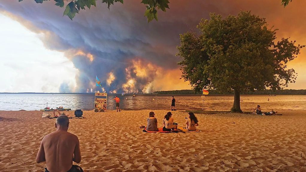

The fires affecting southwestern France and central Spain have already left more than 325,000 people evacuated.
With a record number of hectares consumed, authorities and firefighters continue to make intense efforts to contain the outbreaks that still remain active.
While in Spain the fires that mainly affect the provinces of Ávila and Madrid have already been contained, in the last few hours a new outbreak has emerged in the region of Valencia.
In France, the emergency still cannot be stabilized. Firefighters are currently working to contain a forest fire in the Gironde region, near the city of Bordeaux.
France has been one of the most affected countries, with 42,000 hectares consumed in what constitutes one of the largest fires recorded since the Second World War.
One of the scenes that the fires have left in that country is a huge cloud formation in the sky.
It is a pyrocumulonimbus or a “fire cloud.”
What is it and how is it formed?
According to the BBC's main meteorology presenter, Helen Willetts, this phenomenon is, in essence, a storm caused by a very intense forest fire.
“Forest fires are fueled by hot, dry weather, while strong winds increase the danger by spreading flames very quickly,” he says.
“However, forest fires can also generate their own winds and weather phenomena,” he explains.
Willetts adds that when a large fire burns, it releases enormous amounts of heat. “This heat causes the air above the fire to rise rapidly, dragging smoke, ash and water vapor to the upper layers of the atmosphere.”
As the air rises, it cools and water vapor condenses to form a cloud. If the fire is intense enough and the atmosphere is unstable, that cloud can grow into a towering pyrocumulonimbus, the same type of cloud associated with thunderstorms, he says.
Therefore, if pyrocumulonimbus clouds reach great development, they can also produce lightning, which in turn can cause new fires.
The winds within these clouds, as in storms, are more unpredictable and can spread in all directions. In addition, sometimes they can bring hail and rain.
Scientists describe these clouds as storms generated by fires, since it is the fire itself that provides the energy necessary for the cloud to form and develop.
NASA calls them “the fire-breathing cloud dragon.”
According to the agency, this type of clouds, also called cumulonimbus flammagenitus, are those that are produced “artificially” as a result of a natural heat source, such as a forest fire or a volcano.
"The hot air that comes out of the fire can carry water vapor into the atmosphere and generate clouds. Any type of convective cloud can be created," says the US agency.
According to experts, this type of cloud formation is usually the most dangerous, since by generating a storm cloud, the lightning and winds it causes can cause the fire to spread or cause new fire outbreaks to be generated.
“There is a full-blown thunderstorm forming within the plume of smoke from the fire,” Rick McRae, an associate professor in the bushfire research group at the University of New South Wales (UNSW), told The Guardian. “These phenomena reach approximately 10,000 cubic kilometers of atmosphere, so they have a great impact.”
Are they common?
Australia was one of the first countries to experience the presence of pyrocumulonimbus clouds, at the beginning of the century.
They were also seen in the devastating 2020 fires in California.
That cloud was described by NASA as one of the largest seen in the United States: it was visible from space by the US space agency's satellites, but it was also reported by passengers of several planes passing through the area.
Those who study these phenomena have told French media that these cloud formations seem to become increasingly common.
This would be the first time that this phenomenon has been observed in France.
“It's the first time France has had to explicitly consider the concept of a pyrocumulonimbus,” McRae said.
According to the EU's Copernicus Climate Change Service, Europe is the fastest warming continent, at a rate more than double the global average since the 1980s.
Warmer, drier conditions are reducing vegetation moisture, creating fuel that allows wildfires to start and spread more quickly.
A spark is still necessary—usually from human activity, whether accidental or deliberate, or from lightning—but extreme heat, dry vegetation and strong winds can make fires burn faster and become much more difficult to control.
Forest fires devastated an area this year in Europe greater than the annual average of the last two decades, according to the European Forest Fire Information System.
The European Environment Agency said that “climate change has increased the risk of forest fires across Europe,” with the greatest danger expected to be concentrated in the south of the continent.
Download the new BBC World Service app. Choose BBC News Mundo and receive news alerts, documentaries and analysis, all in one place. Important: The new app is not available in the United Kingdom or the United States.